Big Sur Region Backpacking - June 2003 Photo Gallery
Below is a listing of images and standard GIF images of our backpacking trip along the Big Sur Region between Andrew Molera State Park and Limekiln State Park at the Southern Boundary near Lucia, California. Just past Lucia, we headed up the Nacimiento Road up to the top of the coastal range to our trailhead to Vicente Campground
Big Sur / Central Coast Area - Today, Big Sur is a coastal wilderness. It is as pristine as could be imagined for its 200,000 acres and 90 miles of premium California coast. There are many good trails in this spectacular Region. The coastal range are not as high, but are steeper than the Sierra, but more diverse. Big Sur and the Ventana Wilderness offers a varieties of hikes and challenges.
We visited several parks and only took one or two hikes in each one as we meandering down the coastal highway. You could actually spend a day at any one of these sites and still not see all there is to see. The photos below reflects the different scenes and views we encounter during our hikes. The trails and vistas ranged from beaches, sea caves, tidal pools, cascading river, high falls, secluded cove, redwood forests, and high overlooks. We failed in achieving one of our objective, Peaking Cone Peak, at 5100 ft, the highest point on these coastal range. By clicking on them you will bring up a larger JPEG view of them.
Planning Sidebar
The planning link describes the initial planning and provide links to various site that illustrates the areas we visited.
Pfeiffer Fall and Valley Outlook
The trail to Pfeiffer Fall follow and cross over Pfeiffer creeks several times, winding along a redwood forest all the way to the fall. From the fall, we hiked up the Valley View Trail out of the redwoods into the Oak and chaparral woodland. From an outlook point, you can see the Santa Lucia range, Big Sur Valley, and the Pacific Ocean.
Big Sur Map - Map of the area we visited. We started at the Andrew Molera and visited sites as far south as Kirk Creek just past Lucia.
Pfeiffer Fall Trail - Jeff still smiling at the beginning of our many hikes.
Big Sur River
The Big Sur River is one of the longest coastal California streams to be lined with redwoods. We hike the river from the southern campgrounds located in Andrew Molera State Park back through the canyon for a 1/2 mile. Trouts can be seen in some of the deeper pools in the river. (see pictures below). The trail goes by redwood trees, and as we head deeper into the canyon, requiring us to maneuver over and around many boulders and cascades.
Big Sur River - The trail at the start of the mouth of the river. Here the river is wide and slow
Big Sur River - The troops at the beginning of the hike
Big Sur River - Mid-way, the river up the canyon, the river transform into a pool and small cascading falls.
Big Sur River - Jeff coming over the top on the trail that force us to climb up the canyon wall.
Big Sur River - Another point where we had to scale the wall.
Big Sur River - Who is that person hanging off the tree .
Big Sur River - A view of the river has it comes out of the narrow gorge.
Big Sur River - A trout can be seen in one of the deeper pools.
Big Sur River - Another view of some of the rapids along the river course.
Big Sur River - Phil in his one of his usual - Time to reflect on life - moments.
Big Sur River - Time to take a break and stick our feet in the water.
Big Sur River - How come I always got to cross first??? $#*Q&.
Pfeiffer Beach
"Located on a long narrow and winding road, It is unsuitable for trailer traffic. From a large parking area at the end of the road, a short, well-marked path leads to the beach. Cliffs tower above this breathtaking stretch of sand, and a large arch-shaped rock formation just off-shore makes for some dazzling sunsets."
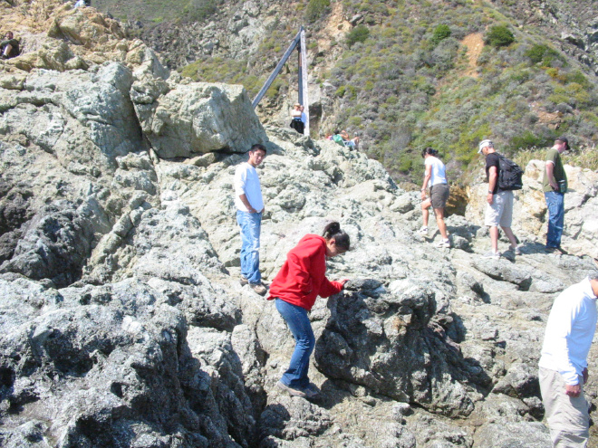
Pfeiffer Beach - The rock formation in the middle of the beach
Pfeiffer Beach - The first glimpse of the tunnels through the rock formation, There are two tunnels in the rock. You can imagine in a thousand years, the two will join, creating a giant Arch formation. The two tunnels are quite large, compare the opening to the people on the side.
Pfeiffer Beach - A Sunset shot by Thai Duong - CSC Toronto
Partington Cove
A steep trail down to the cove, and through a tunnel. Mules used to haul wagons of tanbark through here. Have a seat on a bench at the loading gantry look for sea otters, sea lions, and pelicans. Cross over the highway through a tunnel and another short hike up the mountain for some great view of the coastline.
Partington Cove - Phil standing in the tunnel leading down to the cove
Partington Cove - A closer look at the construction of the tunnel
Partington Cove - A view from the tunnel of the last leg of the trail down to the cove.
Camp Ground
From the start of the drive up from Highway 1 on Nacimiento Road to its junction with the Coast Rd, it was a slow and long 7 miles. Many points on the way gave great views of the coastline. The Coast Road is a very narrow dirt road, a single lane all the way to the trailhead. The hike down was very tiring since we spent all day hiking and climbing.
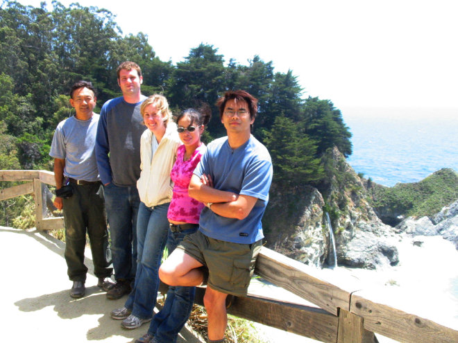
Camp Site - The gang all ready to prepare our evening meal
Camp Site - Jade checking out her new accommodation. "Where my king-size bed???"
Camp Site - This is just as heavy as it was when I carry it down.
Camp Site - Last picture before the hike up the mountain
Camp Site - The rabbits at the car waiting for the turtles to make it back up the mountain.
McWay Fall
Julia Pfeiffer Burns State Park is the home of the McWay Falls, which descends some 80 feet onto a white sandy beach, surrounded by aqua green water. Saddle Rock can be seen in the distance. There is a 1/2 (.8 km) walkway (The Waterfall Trail) that takes you from the parking area to the scenic overlook of the cove. During high tide the ocean water covers the beach and the waterfall flows straight into the sea